
Severe Weather Expected to Return to the Southern Plains and Midwest
A stagnant weather pattern, known as an Omega block, is expected to park itself over the U.S. this week, leading to the return of severe weather from the Southern Plains into the Midwest. This type of weather pattern gets its name because the upper air pattern resembles the Greek letter omega (Ω). The Omega block is characterized by a ridge of high pressure caught in the middle of the country, which will eventually break down and allow for a series of compact storm systems to form in the Rockies and into the Plains.
An Omega block weather pattern is a complex phenomenon that can lead to a variety of weather conditions, including severe thunderstorms, large hail, and damaging winds. As the ridge of high pressure breaks down, it will make room for a more active and progressive jet stream, effectively reopening the “storm corridor.” This transition will allow for the formation of storm systems that will quickly begin to pull rich, unstable moisture from the Gulf of America northward into the heart of the country.
Understanding the Omega Block Weather Pattern
The Omega block weather pattern is a type of blocking pattern that can lead to stagnant weather conditions. It is characterized by a high-pressure system that is trapped between two low-pressure systems, creating a blockage in the atmosphere. This blockage can lead to a variety of weather conditions, including severe thunderstorms, heavy rainfall, and extreme temperatures. The Omega block is a complex phenomenon that requires a deep understanding of atmospheric science and meteorology.
This graphic shows the impacts of the Omega block weather pattern. As the week progresses, the Plains should be prepared for an active stretch of weather, with a Level 2 out of 5 severe storm threat in place for Saturday. This threat includes areas such as Wichita, Oklahoma City, and Wichita Falls. The biggest risk for storms that do develop are large hail and damaging winds, but a few tornadoes are also possible.
Severe Weather Threats and Temperature Expectations
The Omega block weather pattern is also paving the way for soaring temperatures in the Central U.S. As the week progresses, additional days with severe weather impacts are possible. The FOX Forecast Center said above-average rain appears likely for the back half of May. The combination of rich, unstable moisture from the Gulf of America and the energy of the incoming Pacific systems will set the stage for the potential return of severe weather.

This graphic shows the severe storm threat in the Central U.S. for Saturday. The Omega block weather pattern is a complex phenomenon that requires a deep understanding of atmospheric science and meteorology. As the week progresses, it is essential to stay up to date with the latest weather forecasts and warnings to prepare for the potential severe weather threats.
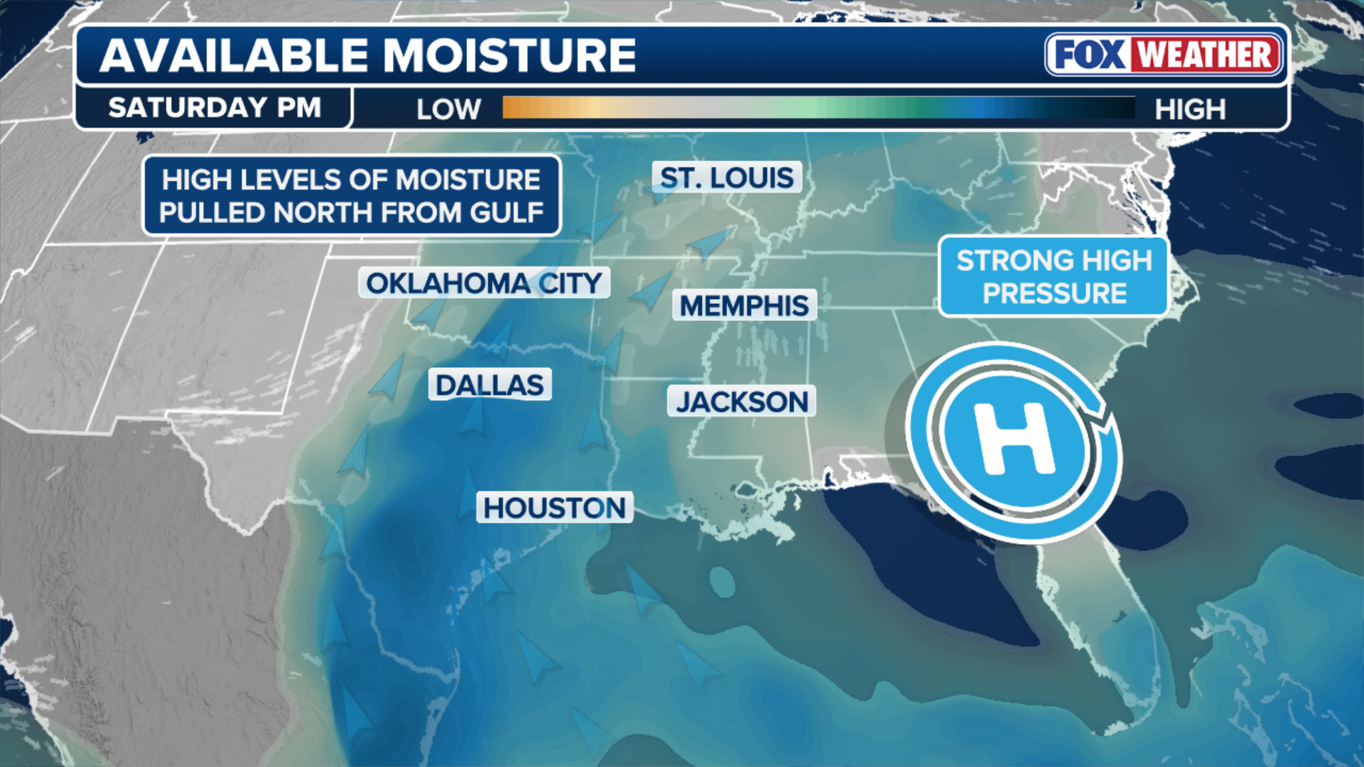
This graphic shows available moisture ahead of possible severe storms on Saturday. The FOX Forecast Center is closely monitoring the situation and will provide updates as necessary. For the latest information on the severe weather threats and temperature expectations, visit the FOX Weather website.
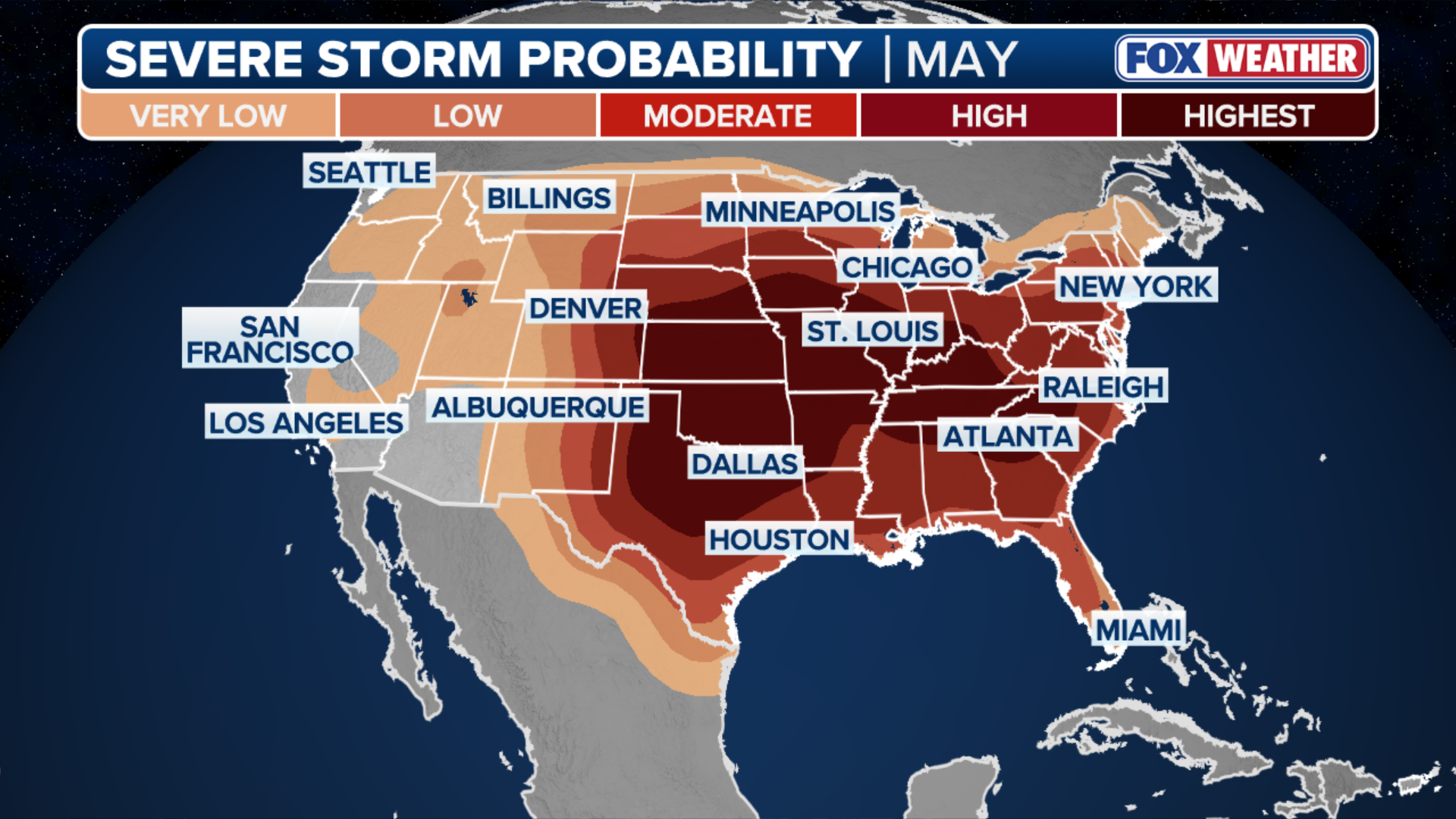
This graphic shows the probability of severe storms across the U.S. in May. The Omega block weather pattern is a complex phenomenon that can lead to a variety of weather conditions. It is essential to stay informed and up to date with the latest weather forecasts and warnings to prepare for the potential severe weather threats.
For more information on the severe weather expected to return to the Southern Plains and Midwest, visit Here
Image Source: www.foxweather.com
