
Unusual Hurricane Season Patterns and Emerging Threats
The 2025 hurricane season has been marked by an unusual pause in tropical activity, with no named storms in the first half of September. This is a rare occurrence, with the last comparable year being 1968, which saw a slow hurricane season with only one hurricane stronger than Category 1. According to satellite data, which has been monitoring the Atlantic since the 1960s, this year’s pause began in August, making it an even more unusual phenomenon.
FOX Weather is your Hurricane HQ
(FOX Weather)
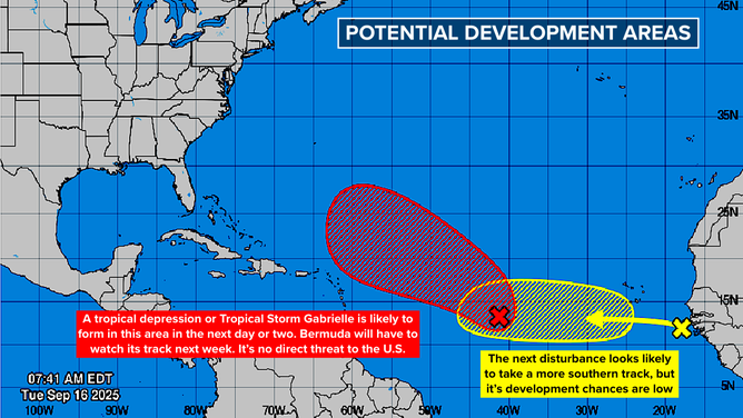
As the Atlantic, Caribbean, and Gulf continue to experience hostile conditions for tropical development, a supportive slot is expected to develop in the central Atlantic, allowing for the formation and intensification of Gabrielle later this week. The National Hurricane Center has high odds of Invest 92L developing into a tropical depression or Tropical Storm Gabrielle, despite the system currently fighting off dust and dry air.
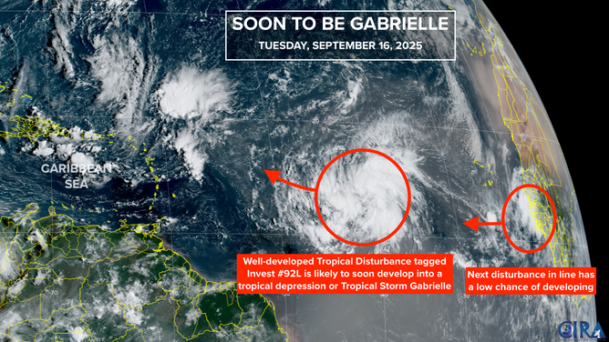
This satellite image provides additional information on Invest 92L in the Atlantic.
(FOX Weather)
Emerging Threats and Forecast Models
The computer forecast models predict that likely-Gabrielle will quickly strengthen as it tracks northeast of the Caribbean islands, potentially becoming a significant hurricane. By the middle of next week, Gabrielle is expected to be in the vicinity of Bermuda, although it’s too early to determine if the threat to the island will materialize. After passing Bermuda, Gabrielle will move into the North Atlantic and dissipate.
Another tropical disturbance has moved off the African coast, which will battle dry air and hostile upper winds. The National Hurricane Center gives this disturbance a low chance of developing into a depression in the next week, with the current consensus of computer models suggesting it will arrive at the Caribbean islands as a moisture surge.
This graphic provides an overview of the tropical Atlantic Basin and development odds for Invest 92L and a new threat off the coast of Africa.
(FOX Weather)
Past Hurricane Events and Current Weather Patterns
Some computer forecast models are picking up on another disturbance that will move off Africa later this week, which may have a better chance of developing. The slow-moving, non-tropical coastal storm battering the Carolinas and mid-Atlantic is protecting the U.S. East Coast from any tropical systems arriving from the east. The steering flow associated with this storm will deflect all tropical traffic to the north.
On this day in 1875, a Category 3 hurricane slammed the town of Indianola, Texas, with wind and storm surge, leaving significant destruction in its wake. The town was rebuilt but was later wiped out by a Category 4 storm in 1886. Due to erosion and sea level rise, the land where the town once stood is now underwater.
For the latest updates and analysis on the 2025 hurricane season, visit Here
Image Source: www.foxweather.com
