
Hurricane Gabrielle Strengthens in the Atlantic
As of the latest update, Tropical Storm Gabrielle has intensified into a hurricane, becoming the second named hurricane of the season. According to the National Hurricane Center (NHC), Hurricane Gabrielle now boasts maximum sustained winds of at least 75 mph, officially designating it as a hurricane. The storm is currently located approximately 320 miles to the southeast of Bermuda and is moving northwest at a speed of 10 mph.
The NHC predicts that Hurricane Gabrielle will undergo rapid intensification, potentially reaching near major-hurricane strength (Category 3 or higher) in the coming days. Rapid intensification occurs when a tropical cyclone’s maximum sustained winds increase by at least 35 mph within a 24-hour period. This phenomenon is closely monitored by meteorologists, as it can significantly impact the storm’s trajectory and potential landfall.  This graphic shows information on Hurricane Gabrielle. (FOX Weather)
Forecast and Potential Impact
While landfall in Bermuda is considered unlikely, residents and travelers are advised to closely monitor forecasts for any changes in the storm’s trajectory. Swells generated by Hurricane Gabrielle are expected to reach the U.S. East Coast, from North Carolina northward, as well as Atlantic Canada, starting later Sunday and lasting through early this week. These swells are predicted to bring dangerous surf and life-threatening rip current conditions to local beaches.  This graphic shows the forecast track for Hurricane Gabrielle. (FOX Weather)
The Atlantic hurricane season, which runs from June 1 to November 30, is a critical period for monitoring tropical activity. The NHC is also tracking two additional areas for potential tropical development in the eastern and central tropical Atlantic Basin. A broad tropical wave is producing limited showers and thunderstorms well to the west-southwest of the Cabo Verde Islands, off the coast of Africa. Although environmental conditions are not currently favorable for development, they are expected to become more conducive by the middle to end of the upcoming week. The NHC has assigned a medium chance of development to this system over the next week.
Additional Areas of Interest
Another area to watch has emerged more than 500 miles to the east of the Windward Islands. This system is producing a small area of disorganized showers and thunderstorms as it moves quickly westward. According to satellite data, the system lacks a closed circulation, and environmental conditions appear only marginally conducive for further development over the next several days. The NHC has assigned a low chance of development to this system over the next week. However, regardless of development, the system is expected to bring gusty winds and showers to portions of the Leeward Islands on Tuesday.  This graphic shows information on an area to watch for tropical development. (FOX Weather)
 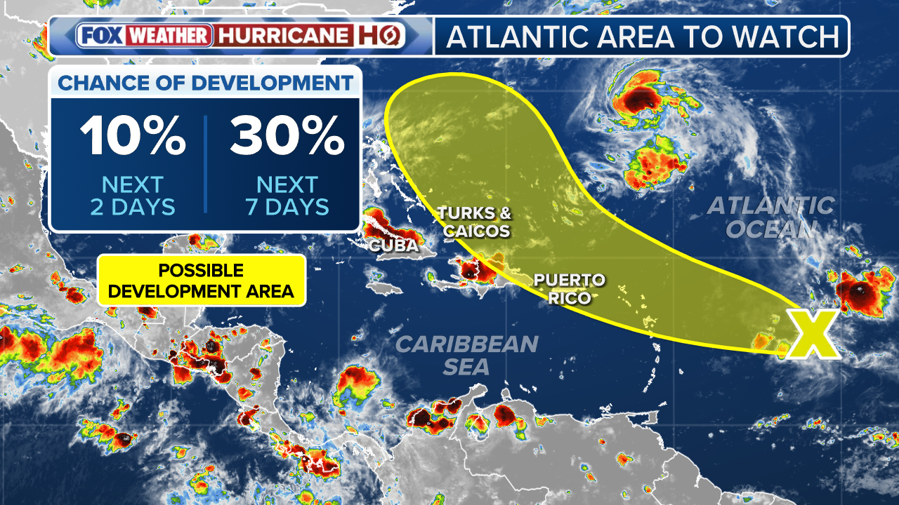 This graphic shows information on a second area to watch in the Atlantic for tropical development. (FOX Weather)
For the latest updates and forecasts on Hurricane Gabrielle and other tropical activity, visit Here
Image Source: www.foxweather.com
