
FOX Weather’s Hurricane HQ: Tracking Potential Storms
As the hurricane season continues, FOX Weather is closely monitoring two areas for potential development. The National Hurricane Center has highlighted these areas, one near Florida and the Bahamas, and the other in the eastern Atlantic. The area near Florida is related to a front that is causing stormy weather over the Florida peninsula, while the area in the eastern Atlantic is related to a robust disturbance emerging off Africa.
FOX Weather is your Hurricane HQ.
(FOX Weather)
According to the latest updates, the disturbance off Africa is the one to watch closely. Satellite imagery shows a tropical wave emerging off the African coast, and computer forecasts indicate that it may develop slowly over the next few days. By next Thursday, some forecasts show the system intensifying, potentially affecting the Caribbean islands.
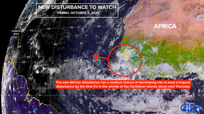
This is satellite imagery of a tropical wave emerging off Africa.
(CIRA / FOX Weather)
Long-Range Predictions and Uncertainty
Long-range predictions for the system’s development and trajectory are uncertain, with forecasts ranging from the Caribbean to the middle of the Atlantic. While most computer forecasts show the system turning north, it’s essential to note that predictions more than a week out are often unreliable. Historically, it’s rare for a hurricane to start in the eastern Atlantic and impact the U.S. in October, with only one instance recorded in modern times – Hurricane Hazel in 1954.
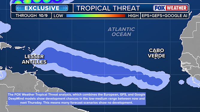
This is FOX Weather’s exclusive Tropical Threat analysis.
(FOX Weather / FOX Weather)
Tropical Threat Analysis and Forecast
FOX Weather’s exclusive Tropical Threat analysis shows the odds of at least a tropical depression forming through next Thursday in the low-medium range. As the situation develops, it’s crucial to stay informed and up-to-date with the latest forecasts and warnings.

This graphic shows the tropical Atlantic.
(Bryan Norcross)
Regional Weather Patterns and Impacts
In addition to the potential tropical development, a non-tropical area of low pressure is forming near the Bahamas, which may contribute to the ongoing rainy pattern over Florida. The combination of this system and an upper-level low pressure system will likely keep the wet weather in place through the weekend. Meanwhile, strong winds blowing off the ocean are causing high seas and coastal flooding along the Southeast coast, particularly in low-lying areas.
For the latest updates and forecasts, visit Here
Image Source: www.foxweather.com
