
Atmospheric River to Bring Heavy Rain and Flash Flooding to California
An atmospheric river is expected to bring heavy rain, strong wind gusts, and potentially feet of mountain snow to California, starting Thursday and lasting through early next week. The storm system is forecast to deliver several months’ worth of rain to Southern California in just a few days, with flash flood warnings covering the Bay Area and Northern California.
The City of Los Angeles has issued evacuation warnings for areas around the burn scars from January’s devastating wildfires, including the Hurst and Sunset Fire burn scars, through Sunday morning. Evacuation orders were also issued for areas around Mandeville Canyon, which was within the footprint of the Palisades Fire. 
What is an Atmospheric River?
An atmospheric river is a long, narrow channel of moisture that flows through the atmosphere, often bringing heavy precipitation to the areas it affects. In this case, the atmospheric river is expected to bring significant rainfall to California, with some areas potentially seeing 3-5 inches of rain through Monday, and localized pockets of 5-8 inches of rain. The San Gabriel and Santa Monica ranges could also see 5-8 inches of rainfall.
The National Weather Service has issued flash flood warnings for several areas in California, including San Francisco and the Bay Area, as well as Sacramento and parts of the Shasta Cascades, Sierra Nevadas, and Gold Country. Thunderstorms with lightning and strong wind gusts are also possible as the storms come onshore. 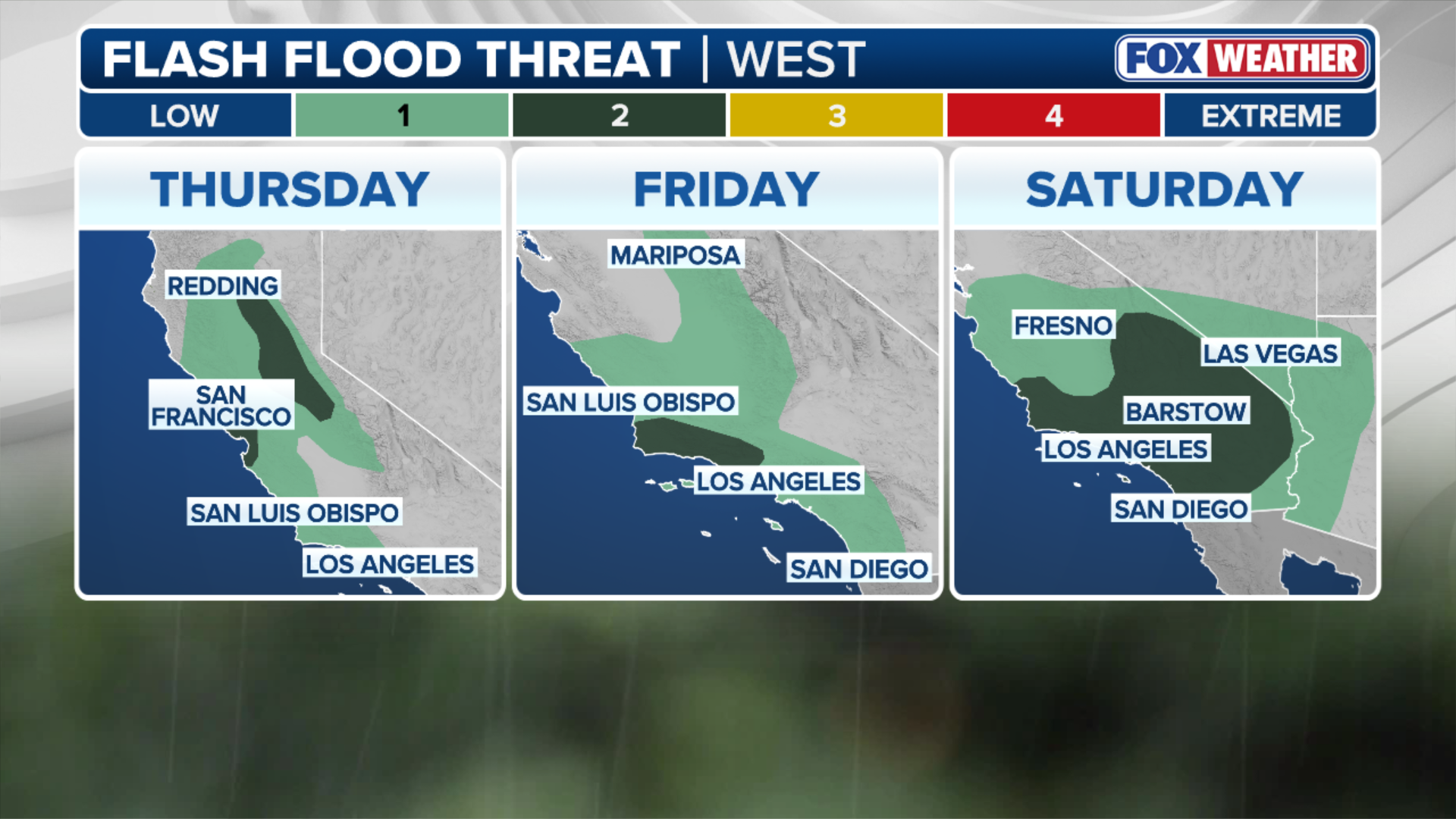 This graphic shows the flash flood threat.
Impact on California
The storm is expected to have a significant impact on California, with the potential for flash flooding, debris flows, and strong winds. The City of Los Angeles has urged residents to be prepared for the storm, and to follow evacuation orders if necessary. The Los Angeles Fire Department has also gone door-to-door in high-risk areas, warning residents of the potential dangers of the storm.
According to the FOX Forecast Center, rain is expected to sweep across coastal California and farther inland in the Central Valley on Thursday. The more intense rain and flood threat will move into Southern California on Thursday night through Friday morning, with a second round forecast to begin on Friday evening.  This graphic shows the expected rainfall.
Winter weather alerts have also been posted for the Sierras through Friday, with some of the highest mountain passes already closed for the season. Wind gusts along ridgetops in the Sierras could exceed 100 mph.  This graphic shows the winter weather alerts.
Preparation and Safety
Residents in affected areas are urged to take necessary precautions to ensure their safety during the storm. This includes following evacuation orders, staying indoors during heavy rainfall, and avoiding travel unless absolutely necessary. It is also important to stay informed about the latest weather forecast and warnings, and to have a plan in place in case of an emergency.
For more information on the atmospheric river and its impact on California, visit Here
-

next
FILE – PACIFIC PALISADES, CA – OCTOBER 14, 2025 — Workers clear debris from a business destroyed in the Palisades fire as scattered downpours, powerful winds and fears of flooding continue to threaten areas of the Pacific Palisades on October 14, 2025. The recent rain prompted evacuation warnings for residents near recent burn areas in the Pacific Palisades.
((Genaro Molina/Los Angeles Times via Getty Images)) -

prevnext
FILE – LOS ANGELES, CALIFORNIA – OCTOBER 14: Water flows past trees in the Los Angeles River, swollen by storm runoff, on October 14, 2025 in Los Angeles, California. A strong atmospheric river storm is hitting Southern California today, triggering evacuation warnings in the Eaton and Palisades fire burn scars due to debris flow fears.
((Photo by Mario Tama/Getty Images)) -

prevnext
FILE – CALIFORNIA, USA – FEBRUARY 6: A woman with an umbrella walks on a road during heavy rain in Guerneville of Sonoma County, California, United States on February 6, 2025 as an atmospheric river hits Northern California.
((Photo by Tayfun Coskun/Anadolu via Getty Images)) -

prevnext
FILE – LOS ANGELES, CALIFORNIA – FEBRUARY, 5: An abandoned car sits in floodwaters during an atmospheric river storm in Los Angeles, California on Monday, February 5, 2024. (Photo by Kyle Grillot for The Washington Post via Getty Images)
( ) -

prev
FILE – A car drives through a flooded street in Rosemead, California, on Oct. 14, 2025.
(Photo by Frederic J. Brown / AFP) (Photo by FREDERIC J. BROWN/AFP via Getty Images)
Image Source: www.foxweather.com
