
Tropical Disturbance in the Eastern Atlantic: A Potential Hurricane Threat
The National Hurricane Center has designated a tropical disturbance in the eastern Atlantic as Invest 95L, indicating that hurricane-specific computer models are now running on the system. According to the latest forecasts, the strong consensus is that the invest will be in the vicinity of the northeastern Caribbean islands east of Puerto Rico by Thursday or Friday. The possibility of the system becoming at least a tropical depression is now in the high range, with computer forecasts generally agreeing that a depression is likely, but the eventual strength of the system remains uncertain.
The possibilities range from a gusty disturbance to a hurricane, with the Google DeepMind AI model providing odds of the various strength possibilities. The model’s strong consensus is that the system will only reach tropical storm strength, and if it develops, its name will be Jerry. The limiting factor appears to be dry air, which dominates the atmosphere over the tropical Atlantic, although the atmospheric pattern around the system is forecast to be reasonably conducive for development, and the water is plenty warm.
Current Weather Conditions and Forecasts
The disturbance is relatively large, so development is likely to be slow and steady. As always, forecasts will become more reliable when and if the system acquires an organized circulation. Around the time the likely-storm reaches the vicinity of the northeast Caribbean Thursday or Friday, a strong dip in the jet stream is forecast to develop over the eastern U.S. once again. 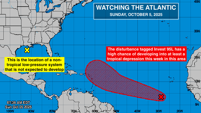 The strong consensus of the computer forecasts is that the depression or storm will be deflected north into the central Atlantic.
Additionally, the National Hurricane Center is also noting a low-pressure system in the northwestern Gulf, which is a non-tropical system and is forecast to move to Texas, bringing enhanced rainfall along the Gulf Coast and some gusty winds. Otherwise, nothing appears to be brewing in the tropics, and the situation will continue to be monitored closely. For the latest updates and forecasts, readers can visit Here for more information.
Image Source: www.foxweather.com
