
Hurricane Melissa: A Catastrophic Threat to Jamaica and the Caribbean
Tropical Storm Melissa is rapidly organizing over the Caribbean, southeast of Jamaica, and is expected to intensify into a hurricane within hours. The storm’s partial eyewall has formed, and with the hostile upper-level winds letting up, rapid intensification is forecast over the near-record warm water. According to the National Hurricane Center, Melissa will likely reach high-end Category 4 or Category 5 strength before making landfall.
FOX Weather is your Hurricane HQ.
(FOX Weather / FOX Weather)
The current forecast track shows an extreme threat to the eastern half of Jamaica, with catastrophic damage likely from feet of torrential rain and Category 4 or 5 winds. The assault will last more than two days, which is hard to imagine. Landfall is still about 2 1/2 days away, so the forecast track can still shift. However, any reasonable alternate path would still produce a foot and a half to 3 feet of rain across the eastern two-thirds of the island, leading to widespread catastrophic flooding and mudslides.
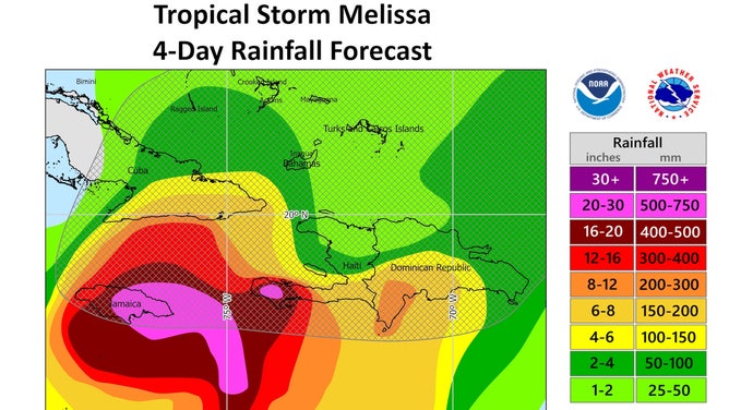
Rainfall forecast.
(NOAA / FOX Weather)
Forecast and Track
There is general agreement on the predicted track among the computer forecast models, including the European (ENS) and the Google DeepMind AI-based forecast. All forecast an extreme threat to the eastern half of the island. The yellowish and reddish areas show the forecast diameter of the winds of various strengths at 2 a.m. on Tuesday, with hurricane-force winds forecast to be over the Kingston metropolitan area at that time.
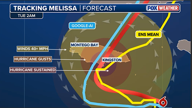
Tracking Melissa.
(FOX Forecast Center / FOX Weather)
Impact on Jamaica and the Caribbean
South of Jamaica, the Caribbean water is extraordinarily warm, and the atmospheric pattern is forecast to be conducive to dramatic, rapid strengthening of the system. The National Hurricane Center is forecasting Melissa to reach high-end Category 4 or Category 5 strength before it turns north. The current consensus track shows an extreme threat to the Kingston metropolitan area from flooding rain, wind, and storm surge.
Kingston Harbor opens to the south, and the airport is on a peninsula in the harbor. Storm surge up to 10 feet above normal high tide is forecast for somewhere on the southern coast of Jamaica east of where the center comes ashore. If that occurs in Kingston or just west of the city, there will be widespread damage to critical infrastructure.
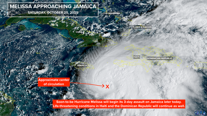
Melissa approaches Jamaica.
(CIRA / FOX Weather)
Other Affected Areas
Extreme rainfall is also forecast over the Tiburon Peninsula in southwest Haiti, with heavy rain in other parts of the country as well. Significant flooding has already occurred along the south coast of the Dominican Republic, including in Santo Domingo. Additional rainfall is expected. Melissa will likely be weakened by its trek over the high terrain on Jamaica, but will still be a formidable storm when it makes landfall late Tuesday or early Wednesday in eastern Cuba.
The Cayman Islands look to be outside of the extreme threat zone, although fringe effects are possible, especially in the waters around the islands. Puerto Rico is on the edge of the moisture feed, and spotty tropical downpours could still occur until the storm moves west. Everybody in the affected areas should put maximum effort into finding a safe place where the floods can’t reach them.
For the latest updates and forecast, visit Here
Image Source: www.foxweather.com
