
Tropical Disturbance in the Atlantic: A Potential Threat to the Caribbean
According to the National Hurricane Center, a tropical disturbance in the central Tropical Atlantic has a chance of developing into a tropical depression or storm. FOX Weather Hurricane Specialist Bryan Norcross breaks down the latest updates on this potential threat. The disturbance is currently located in the central Tropical Atlantic and is forecast to move into the southeastern Caribbean, specifically over the Windward Islands, by Sunday or Monday.
Current Status and Forecast
The National Hurricane Center has tagged the area as an “Area to Watch” with a possibility of development. The long line from the disturbance’s current location to the eastern Caribbean indicates that development is not expected before the system reaches the vicinity of the islands. The disturbance is tracking west at a very low latitude, especially for October, which increases the possibility of land interaction with South America.
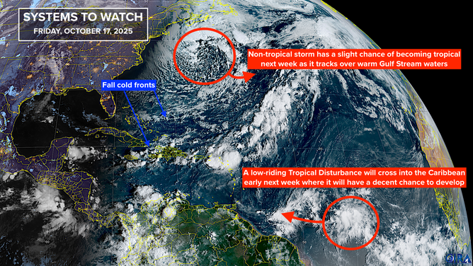
This is satellite imagery of the tropical Atlantic.
(CIRA / FOX Weather)
Potential Scenarios and Impacts
The computer forecast models paint two possible scenarios: one where the depression, storm, or hurricane meanders around the southern or western Caribbean for several days, and another where it is scooped up by a dip in the jet stream over Florida and pulled north over the northern Caribbean islands. The odds of the second scenario have increased, but it’s essential to note that this assumes the system develops at all.
There is currently no indication of a threat to Florida or the mainland U.S., but it’s crucial for everyone in Jamaica, Puerto Rico, and the surrounding islands to stay aware of the situation. Some computer forecasts show a storm lingering in the Caribbean for the rest of the month.
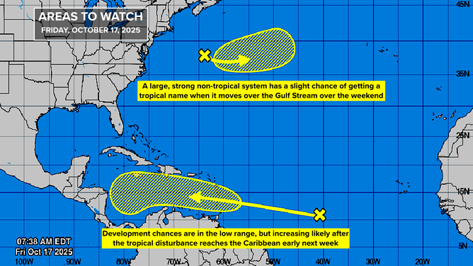
This graphic shows the tropical Atlantic.
(Bryan Norcross)
Another System to Watch
A large low-pressure system is located well offshore of the Mid-Atlantic and south of Atlantic Canada, producing winds of at least 60 mph. This system is pushing the latest cold front south and has a short window of opportunity to develop into a tropical-type system over the warm Gulf Stream waters. If it develops, it will be named Melissa.
However, the National Hurricane Center has the odds of development in the very low range due to the system’s short window of opportunity and the impending cold water ahead.
For the latest updates and forecast, Here
Image Source: www.foxweather.com
