
Severe Thunderstorms and Flash Flooding Threaten Thanksgiving Travel Across the Southern United States
A line of strong thunderstorms raced across north Texas, Oklahoma, and Arkansas early Monday morning, bringing powerful wind gusts and heavy rain to the Interstate 20 and Interstate 35 corridors, as an estimated 73 million people begin to travel for the Thanksgiving holiday.
Repeated rounds of rain on Monday will bring rain to the Interstate 20 and Interstate 35 corridors. More severe storms are expected to threaten early Thanksgiving flights in these same areas on Monday afternoon, as storms begin to shift east. A broad low-level flash flood threat stretches from Austin to Nashville, Tennessee.
Supercell Thunderstorms Bring Damaging Winds and Large Hail
This same weather system delivered powerful severe weather to West Texas, including a supercell thunderstorm in Grandfalls, Texas, on Sunday afternoon. Supercells are thunderstorms that have the power to produce damaging winds, large hail, and tornadoes.

More than 485 flights were delayed into or out of Dallas Fort Worth International Airport on Sunday, according to aviation-tracking company FlightAware.
Travel Forecast and Severe Weather Threat
A second round of thunderstorms is expected to develop on Monday afternoon, which will move across North and East Texas. These storms also carry the potential to develop supercells. According to the FOX Forecast Center, drivers traveling Interstate 20 from Shreveport, Louisiana to Alexandria, Louisiana will likely see the worst impacts from those storms.
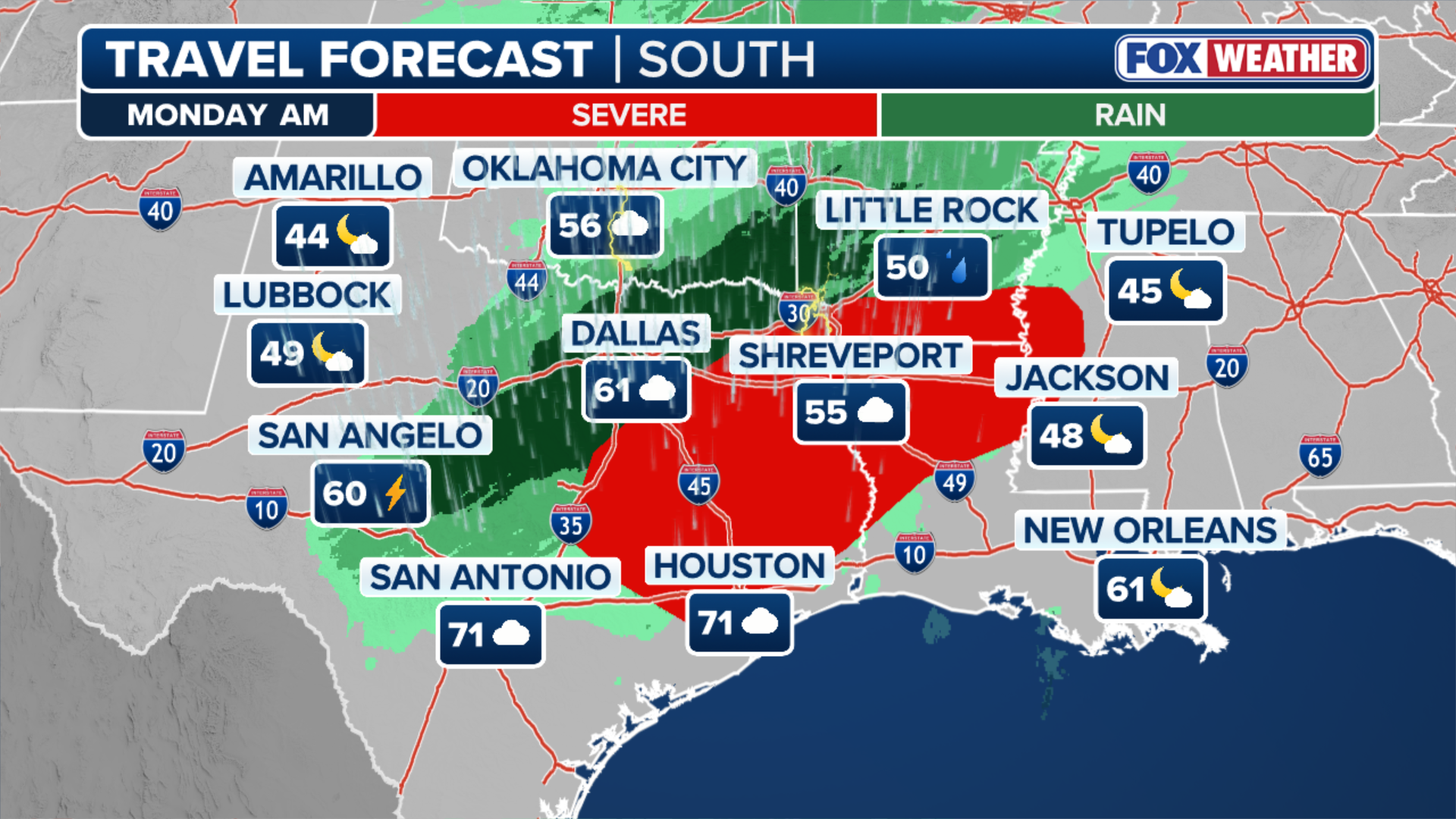 Travel forecast.
(FOX Weather)
NOAA’s Storm Prediction Center has issued a Level 2 out of 5 risk of severe thunderstorms covering parts of East Texas, northern Louisiana, southern Arkansas, and eastern Mississippi. Houston is just outside the Level 2 risk but could still see strong storms on Monday afternoon.
 Severe weather threat for Monday, Nov. 24, 2025.
(FOX Weather)
Flood Watch and Flash Flood Threat
A Flood Watch covers parts of North Texas, including the Dallas Metroplex through Monday afternoon, as these storms repeatedly soak many of the same areas. According to the FOX Forecast Center, most of these areas can expect 1-3 inches of rain through Monday.
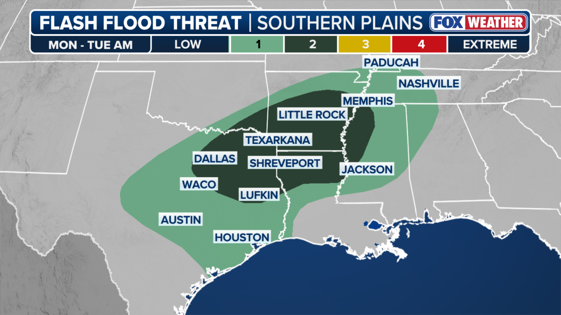 Flash flood threat for Monday, Nov. 24, 2025.
(FOX Weather)
The greatest flood threat is concentrated in the Ark-La-Tex region, where NOAA’s Weather Prediction Center has issued a Level 2 out of 4 Flash Flood Threat that includes Dallas, Shreveport, Louisiana, Little Rock, Arkansas, Jackson, Mississippi, and Memphis, Tennessee.
Travel conditions improve for Texas on Tuesday as storms shift east, with the heaviest rains blanketing Alabama, Tennessee, and parts of Georgia, including Atlanta’s Hartsfield-Jackson Airport, the country’s busiest airport by volume.
For the latest updates on the severe weather threat and travel forecast, visit Here
Image Source: www.foxweather.com
