
Understanding the Central American Gyre: A Potential Source of Hazardous Weather
As the peak of the Atlantic hurricane season comes to a close, meteorologists are shifting their focus to the waters surrounding Central America, where a broad area of low pressure known as the Central American Gyre (CAG) could form in the coming weeks. This phenomenon has the potential to trigger a range of hazardous weather conditions, including tropical cyclones, torrential rain, flooding, and mudslides.
A Central American Gyre typically develops once or twice during the hurricane season, often in the early and late months. Even without spawning a named tropical system, the sprawling circulation can bring days of heavy rainfall and flooding to more than a dozen countries across the Americas. The broad pattern can last for several days and more than a week, allowing copious amounts of tropical moisture to accumulate across the region.
Central American Gyre
(FOX Weather)
What is a Central American Gyre?
Forecast models this year are again showing signs of a potential broad area of low pressure developing over Central America. However, the FOX Forecast Center emphasizes that tropical development is far from guaranteed and will depend heavily on upper-level wind patterns. The greatest concerns are often caused by heavy rainfall and prolonged moisture, which can lead to devastating mudslides and flash flooding.
Researchers at the National Weather Service’s Environmental Modeling Center have previously noted that the Global Forecast System (GFS) computer model often over-predicts the formation of tropical cyclones in the western Caribbean linked to gyre activity. In other words, the model sometimes depicts tropical development that never actually materializes.
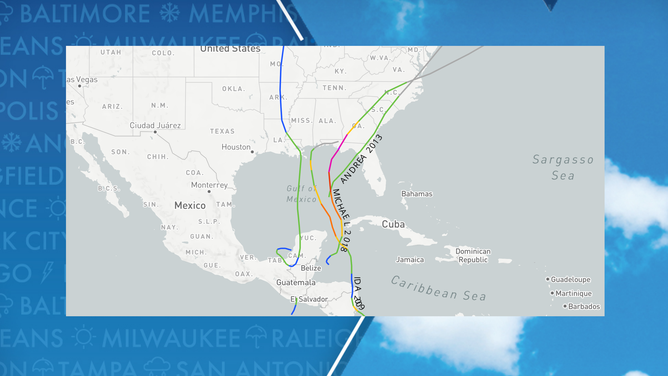
Central American Gyre-influenced cyclones
(FOX Weather)
History of Significant Storm Systems
The Central American Gyre has a long history of producing significant storm systems. About once every other year, a tropical cyclone emerges from one of these gyres and strengthens into a hurricane if atmospheric conditions allow. Some of the most notable examples include Hurricane Michael (2018), which struck the Florida Panhandle as a Category 5 hurricane after spending days embedded in a Central American Gyre. Tropical Storms Amanda and Cristobal, both in 2020, also developed from similar setups, as did Tropical Storm Andrea in 2013 and Hurricane Ida in 2009.
Because the formation zones often include the Gulf and Pacific, storms generated from gyres can pose threats not only to Central America but also to the U.S. Southeast coast. With several weeks left in the official hurricane season, the FOX Forecast Center will continue to monitor the region closely.
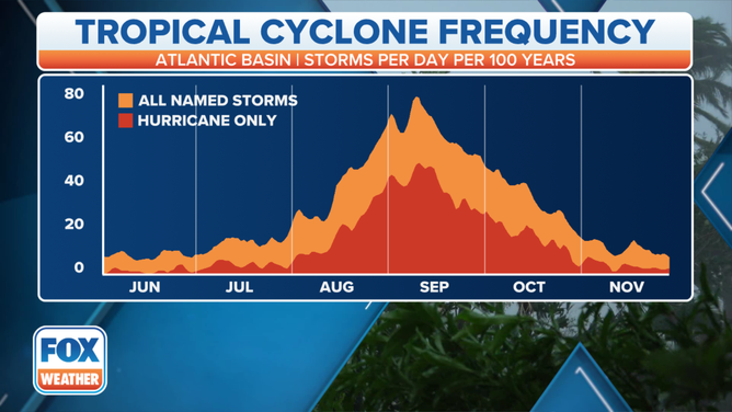
When hurricanes, or tropical cyclones, are typically most frequent in a calendar year.
(FOX Forecast Center / FOX Weather)
For the latest updates and forecasts, visit Here
Image Source: www.foxweather.com
