
New Year’s Day Forecast: Winter Weather to Continue Across the US
Syracuse has nearly doubled its yearly average snow records so far this season with 76 inches reported. More snow is on the way through New Year’s Day as a lake-effect snow storm rattles the Great Lakes.
Syracuse has nearly doubled its yearly average snow records so far this season with 76 inches reported. More snow is on the way through New Year’s Day as a lake-effect snow storm rattles the Great Lakes.
As we step into 2026, many hope for positive change, but winter weather shows no signs of switching up. Colder weather will continue to hold a firm grip across the Northern Tier, with temperatures well below average and dangerous wind chills. Wind chills will be a significant factor as temperatures are expected to drop to 10 to 15 degrees, according to the FOX Forecast Center. Wind chills could reportedly dip near zero in locations such as Bismarck, North Dakota and Buffalo, New York.

Parts of Upstate New York were covered in heavy snowfall after the region began the week with intense winter weather conditions.
Lake-Effect Snow and State of Emergency
This comes just after parts of Upstate New York experienced powerful lake-effect weather conditions from Sunday through Tuesday. Cold arctic air moved into the Northeast at the start of the work week and was in full effect on Tuesday. Due to the ongoing lake-effect snow on Monday, much of the region was under a State of Emergency as intense winter conditions brought dangerous winds.
Locations such as Syracuse, New York, broke a record for the second-snowiest day, with 24.2 inches in one day. This also marks the snowiest December day on record for the city.

Snow falls fast in Syracuse, New York thanks to a powerful winter storm that has much of Upstate New York and the Northeast on high alert amid a state-of-emergency declared by Gov. Kathy Hochul in over 35 counties in the Empire State.
Southern States to Experience Warmer Weather
Luckily for Americans in the South, the cold blast won’t last past Thursday, as warmer weather is expected to fill in by Friday, according to the FOX Forecast Center. Morning temperatures on Thursday will remain chilly, especially in Florida. Frost and freeze alerts will remain active for the Sunshine State through Thursday morning.
By New Year’s Day, temperatures are expected to return to near-average levels, with cities such as Miami expected to reach a pleasant 69 degrees. In contrast, Houston, Texas, is expected to reach 74 degrees.
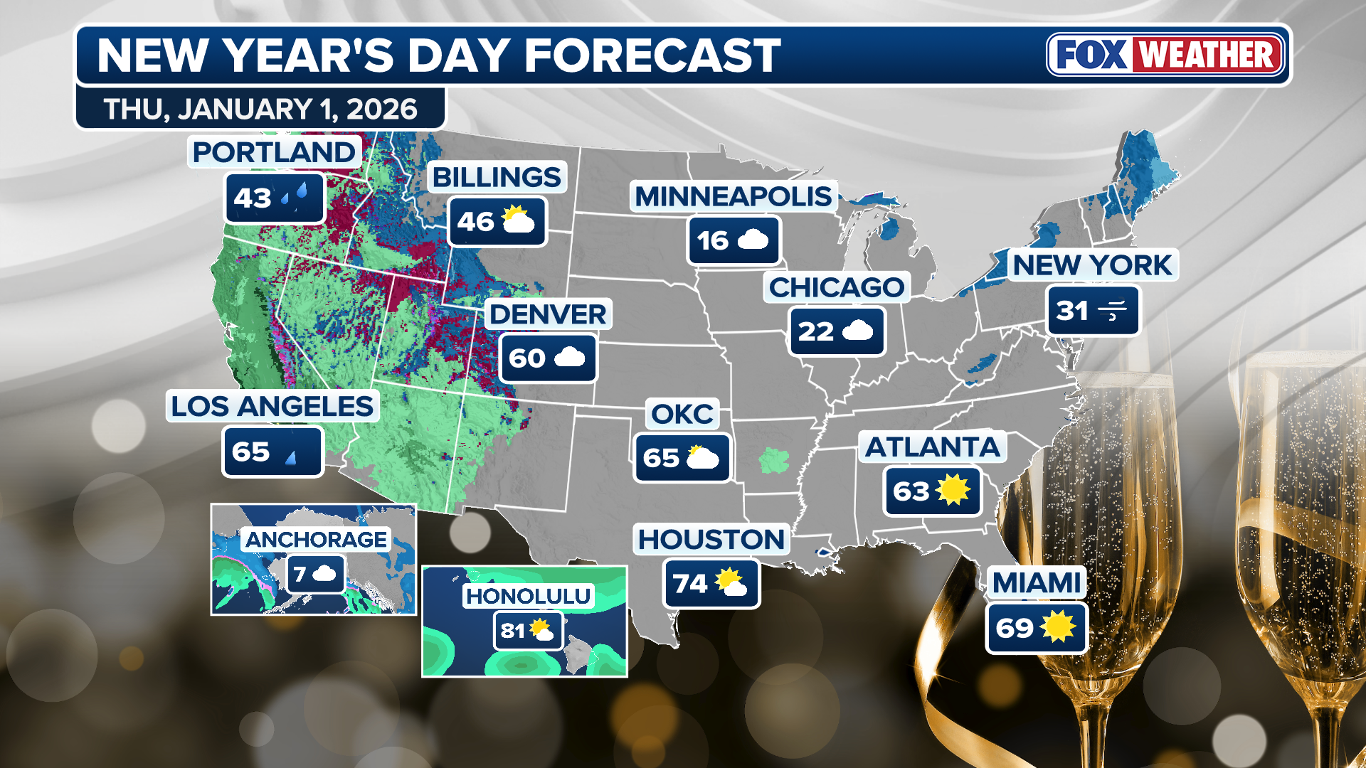
This graphic shows the forecast in United States for New Year’s Day.
(FOX Weather)
West Coast to Experience Wet Weather
The West Coast will experience a different kind of New Year’s celebration as parts of California could have more wet weather on the way. This comes just after historic rainfall plagued the state, causing heavy flooding and landslides on Christmas Eve.

Historic holiday flooding in Wrightwood, California on Christmas Eve left entire cars and houses submerged in debris.
Evacuation warnings were issued for people near burn scar areas where flash flooding was likely. On New Year’s Day, cities such as Los Angeles can expect temperatures of 65 degrees and rain. San Francisco will also see rainfall, with temperatures near 58 degrees. The city is under a Coastal Flood Advisory until Sunday.
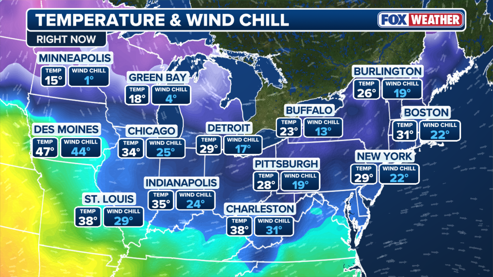
This graphic shows the forecast temperatures across the Northern Tier and Midwestern United States.
(FOX Weather)
If you are located in the Upper Midwest, a fast-moving clipper could bring light snow to parts of Minnesota, North Dakota and Michigan on Thursday, according to meteorologists at the FOX Forecast Center. Light snow is also possible for Chicago. If you’re going outside on New Year’s Day, make sure to dress warmly to avoid serious health risks, such as hypothermia and frostbite.
For the latest forecast, check Here
Image Source: www.foxweather.com
