
Winter Storm Alert: Potential for Impactful Snow and Ice Across the South
The FOX Forecast Center is closely monitoring the potential for impactful snow and ice across the South by late week, with possible effects extending into parts of the East Coast. While specific impacts haven’t completely come into focus, confidence is increasing that a developing system could take advantage of the widespread cold air expected to dominate much of the country.
The FOX Forecast Center is closely monitoring the potential for impactful snow and ice across the South by late week, with possible effects extending into parts of the East Coast. While specific impacts haven’t completely come into focus, confidence is increasing that a developing system could take advantage of the widespread cold air expected to dominate much of the country.
Previous Snowfall and Current Weather Conditions
The FOX Forecast Center is monitoring the potential for an even more powerful winter storm that could deliver snow and ice from Texas to the Southeast Coast by late week, after parts of Florida, Alabama, and Georgia saw rare snow accumulation over the weekend.
PHOTOS: HOURS OF RARE SNOWFLAKES IN SOUTH END AS STORM CHARGES UP THE EAST COAST, DUMPING INCHES OF SNOW
A narrow corridor of up to 3 inches of snow fell across parts of southeastern Georgia this weekend, while Marianna, Florida in the Florida Panhandle recorded 1.3 inches of snow.
Pensacola, Florida managed to hold on to 0.2 inches of snow.
This is the first time some places in the Panhandle have seen snow in back-to-back winter seasons.
Forecast and Potential Impacts
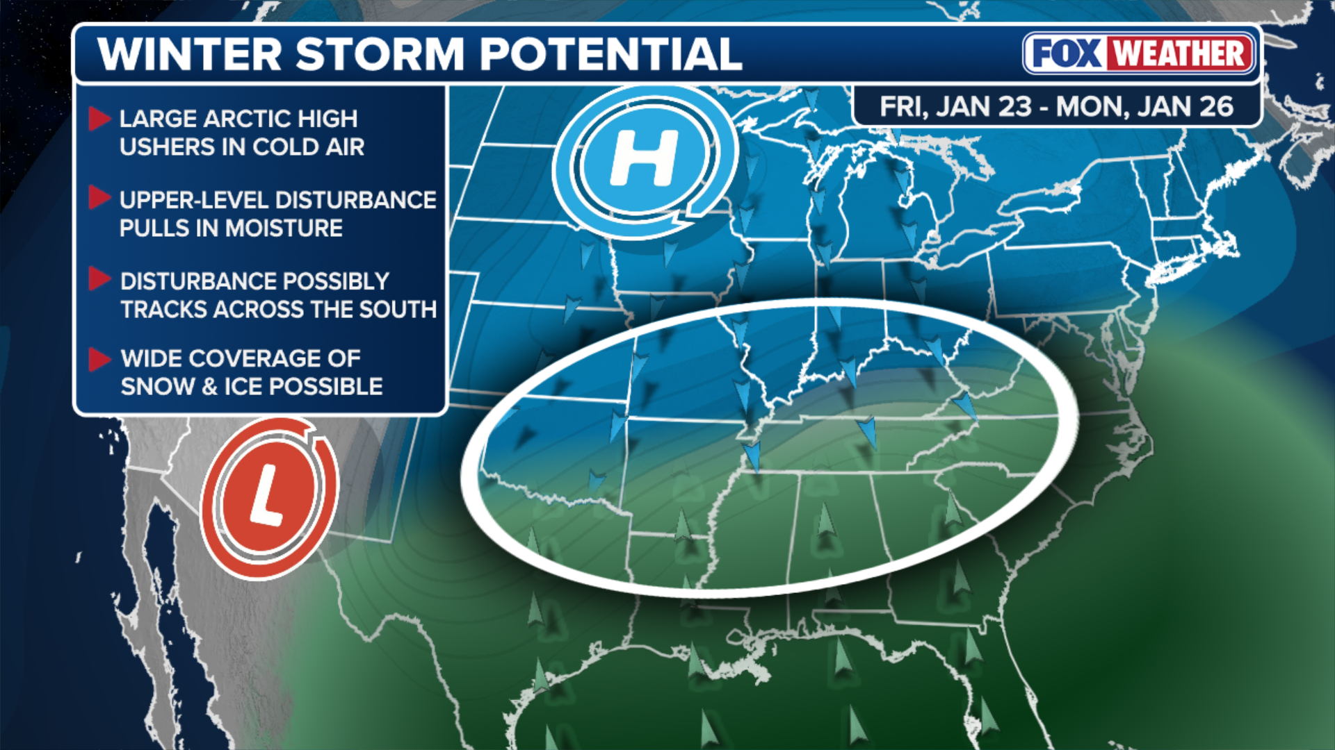
This graphic shows where a brewing winter storm could potentially develop later this week.
(FOX Weather)
Freeze Warnings remain in effect for most of Northeast and north-central Florida through Monday.
HOW COLD DOES IT NEED TO BE IN FLORIDA FOR IGUANAS TO FALL FROM TREES?
Several shots of Arctic air will spill across most of the Lower 48 this week due to a persistent dip in the jet stream.
This cold air will set the stage for the late-week winter storm brewing for much of the Southern Plains and Deep South.
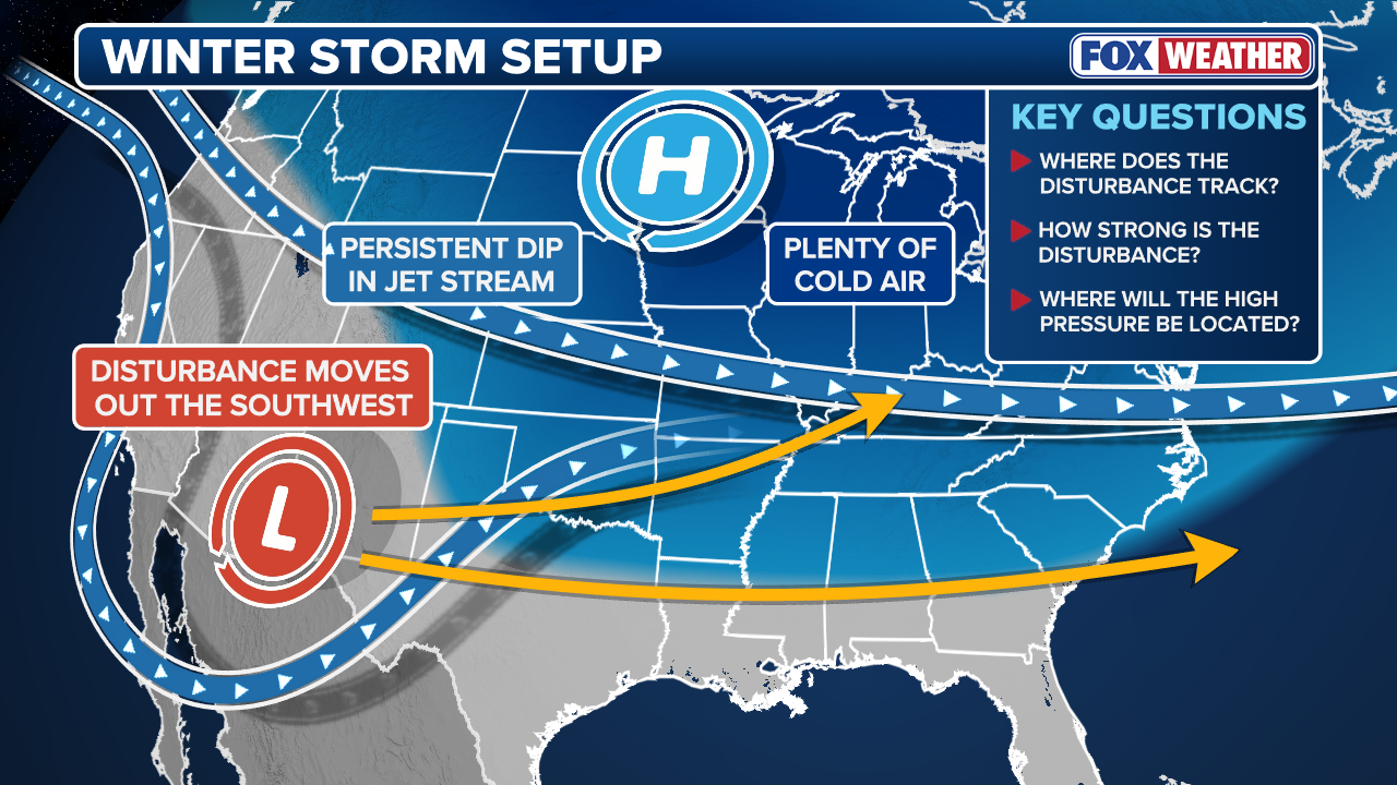
A storm will track out of the Southwest later this week and take advantage of cold air across the South.
(FOX Weather)
The southerly track of this storm will draw in moisture from the Gulf and create the potential for snow and ice.
POLAR VORTEX TO FUEL DANGEROUS SPREAD OF ARCTIC AIR AS COLDEST TEMPERATURES WILL LINGER OVER US FOR WEEKS
Potential Ice Threat and Winter Storm Outcomes
However, the exact impact of this system will depend on its track and the amount of cold air in place, details that will become clearer later this week.
According to the FOX Forecast Center, several general outcomes are possible.
“Snow would likely develop north of the system’s track, rain would fall to the south, and a potentially impactful zone of ice could set up in between,” the FOX Forecast Center said Monday.
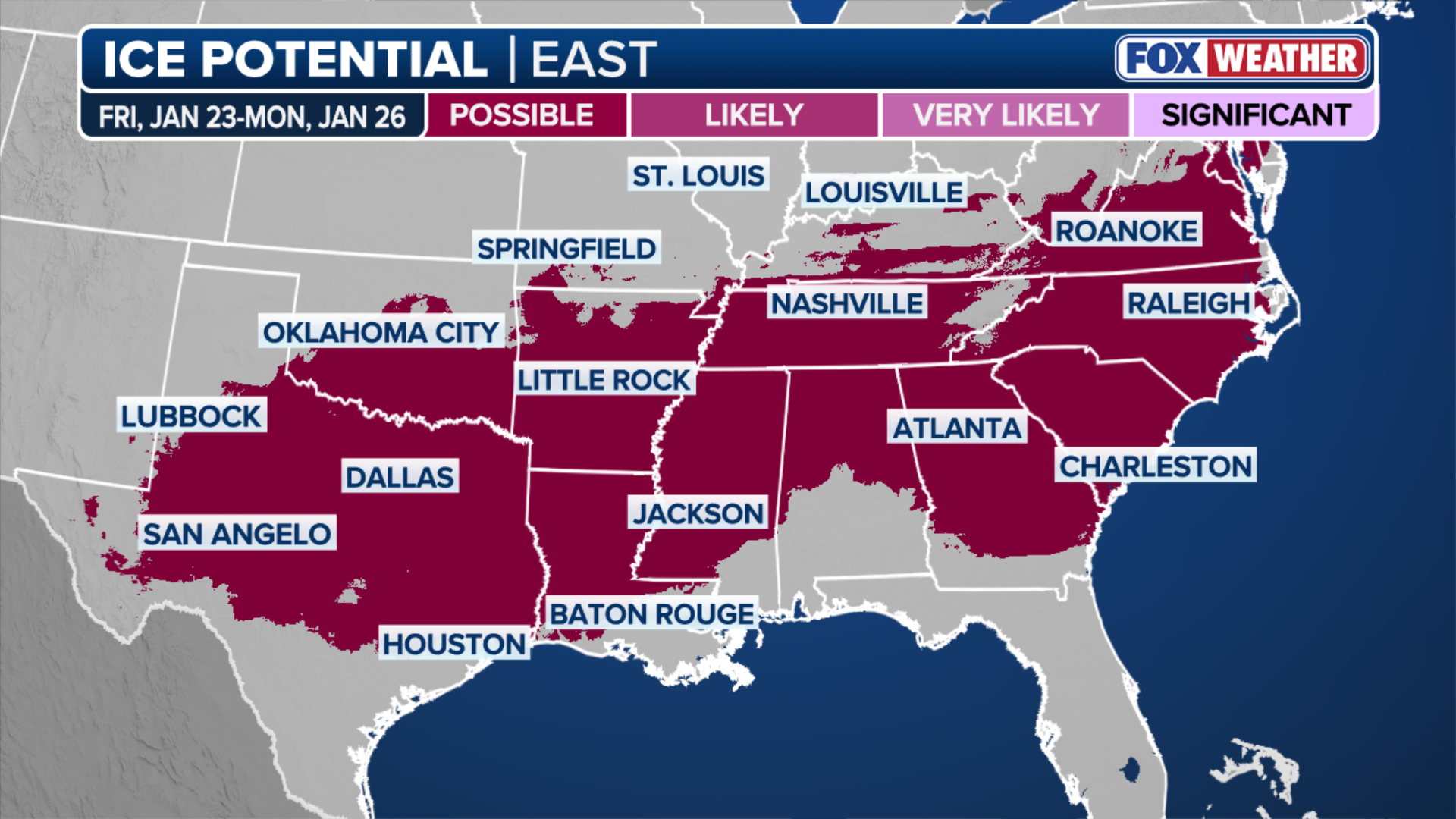
Ice Potential
(FOX Weather)
“It is far too early to assess the severity of any ice threat, but the pattern warrants close attention, as this is a classic setup for disruptive icing due to the combination of deep moisture and cold air.”
The FOX Forecast Center highlighted the potential for a widespread ice threat covering Texas, the Lower Mississippi and Tennessee valleys, the Southeastern Coast, and even parts of the Mid-Atlantic and Washington, D.C.
Check back for updates on this developing story.
For the latest updates on the potential winter storm, visit Here
Image Source: www.foxweather.com
