
Potential Tropical Cyclone Nine Forms in the Atlantic
The National Hurricane Center has designated Potential Tropical Cyclone Nine in the Atlantic, prompting officials to issue alerts for the central Bahamas and watches for the northwestern Bahamas.
Located in the vicinity of eastern Cuba and the southeastern Bahamas, PTC Nine has winds of 35 mph. The system is forecast to become a tropical depression on Saturday and then Tropical Storm Imelda on Saturday night or early Sunday, according to the NHC.  Potential Tropical Cyclone Nine.
(FOX Weather)
Forecast and Potential Impacts
There is tremendous uncertainty in the forecast track at this time due to multiple factors, including the proximity of strengthening Hurricane Humberto. FOX Weather Hurricane Specialist Bryan Norcross notes that computer models are split on whether likely-Imelda will directly hit the U.S. mainland.  Current Tropical Alerts.
(FOX Weather)
Norcross emphasizes that forecasts for just-developing systems are subject to large errors and are likely to change. “There is a strong consensus in the various computer forecasts that Imelda will likely track to the north, paralleling the Florida coast at least through the weekend,” Norcross said Friday. “About Monday, however, it looks likely to face a fork in the road. Either it will turn right, out to sea, or it will arc left into the Georgia, South Carolina, or North Carolina coast.”  Potential Tropical Cyclone Nine Forecast Cone.
(FOX Weather)
States Prepare for Potential Impacts
South Carolina Gov. Henry McMaster said Wednesday that the state’s emergency management division is working with the National Weather Service to monitor developments. The City of Charleston announced Friday that stormwater pumps had been deployed, and local lake levels had been lowered, among other preparations. 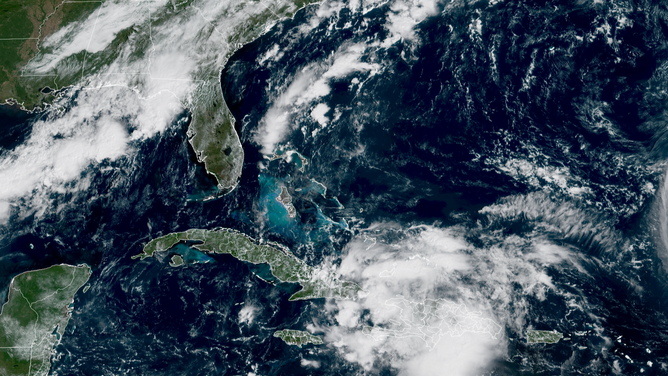
This is satellite imagery of Invest 94L.
(CIRA / FOX Weather)
Duke Energy, which services power to 80 counties in North Carolina, says a significant portion of the storm’s possible paths are in their service area. “Our in-house team of meteorologists is following the path of that storm, and we use that forecast to power our damage modeling system,” spokesperson Jeff Brooks told FOX Weather.
Torrential Rains Threaten Dangerous Flooding in Caribbean
PTC 9 is expected to bring several inches of rain to the Bahamas and nearby Caribbean Islands, prompting flash flooding threats. Eastern Cuba is expected to get the worst of the rain, with about 8-12 inches in general, and some spots receiving up to 16 inches. About 4–8 inches are expected in the Bahamas, and 2-4 inches in Jamaica and Hispaniola. “This rainfall will likely produce flash and urban flooding. Mudslides are also possible in areas of higher terrain across eastern Cuba, Hispaniola, and Jamaica,” the NHC said.
For the latest updates and information on Potential Tropical Cyclone Nine, visit Here
Image Source: www.foxweather.com
