
Severe Weather Forecast: Showers and Thunderstorms to Hit the Northeast
A stout cold front is expected to sweep through the eastern United States on Saturday, bringing the threat of damaging winds and hail to the Interstate 95 corridor. The Storm Prediction Center has placed much of the corridor under a slight risk for severe weather, stretching from eastern Pennsylvania and Maryland into southern New England.
According to the FOX Forecast Center, showers may develop during the morning, but the bulk of the heavier activity is likely to be triggered by heating during the afternoon. The stronger thunderstorms will be capable of producing wind gusts up to 70 mph as well as some small hail. Cities where the stronger activity may occur on Saturday include Boston, New York City, and Philadelphia.
Showers and thunderstorms are likely along the Interstate 95 corridor on Saturday.
Severe Weather Risks and Alerts
The SPC, in coordination with local National Weather Service offices, has the capability of issuing severe weather alerts such as Severe Thunderstorm Watches and Tornado Watches hours ahead of an event. A Severe Thunderstorm Watch means the atmosphere is conducive for the development of storms that could produce hail the size of quarters or larger and winds of 58 mph or greater.
Heavy rainfall is not expected to be a flooding concern, as more than 70% of the region is either unusually dry or officially in a drought. The same frontal boundary triggering the storms produced severe weather across the Tennessee Valley on Friday, which included hail the size of tennis balls and winds that knocked over several trees.
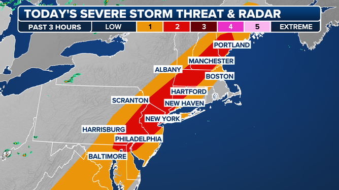
Saturday severe weather forecast 9/5/2025
(FOX Weather)
Cold Front to Bring Temperature Drop and Coastal Impacts
Once the front pushes through, temperatures will drop by 10 to 20 degrees and remain below normal values for an extended period. For instance, Central Park, which is expected to reach the mid-80s on Saturday, will only top out in the lower 70s on Sunday once the cold front moves through.
Waves of between 10-15 feet were expected along Lake Michigan as a significant frontal boundary moved through during the end of the week. Video out of Grand Haven, Michigan shows the coastal impacts.

Waves of between 10-15 feet were expected along Lake Michigan as a significant frontal boundary moved through during the end of the week. Video out of Grand Haven, Michigan shows the coastal impacts.
Outlook for the Upcoming Week
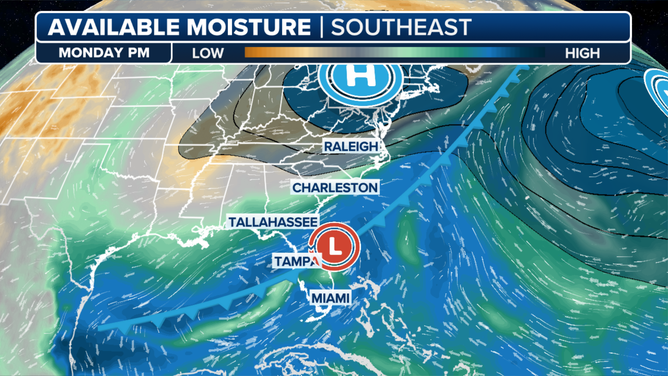
The cold front is expected to stall off the East Coast, and while it’ll be far enough offshore the Northeast to limit impacts, the Southeast could see several rounds of heavy rain and rough surf through the upcoming workweek.
Cold front exists the East Coast over weekend but stays close by.
(FOX Weather)
For the latest updates on the severe weather forecast, visit Here
Image Source: www.foxweather.com
