
Relief from Drought Conditions: Significant Snow and Rain Expected in the West
After weeks of drought conditions, the Western United States is expected to experience significant mountain snow and rain in the lowlands, bringing much-needed relief to the region. A large dip in the jet stream is anticipated to stall over the West, opening the door to active weather patterns.
Multiple rounds of mountain snow and heavy rain are forecasted for the West, providing relief to the current drought conditions that have plagued multiple states with the worst snow drought in decades. The Upper Colorado Basin is facing an all-time record low amount of snow for this time of year, with Salt Lake City, UT, and Grand Junction, CO, experiencing 330 and 442 days without 1 inch of snow, respectively.
Expected Weather Patterns and Impacts
FLASH FLOODING, SEVERE STORMS BREWING FOR SOUTH FROM MASSIVE CROSS-COUNTRY STORM. In an aerial view, patchy snow remains on a golf course, which is normally used for cross-country skiing in the winter, on February 9, 2026, in Park City, Utah.  (Mario Tama/Getty Images / Getty Images)
A large dip in the jet stream is expected to stall over the West starting Sunday, allowing for an active weather pattern to kick in. This will open the door for multiple storms to bring in much-welcome snow to the mountains and rain to the lowlands. The system will begin in California as a strong area of low pressure will slam the region, fueling multiple subsequent storms that will funnel in more heavy rain. 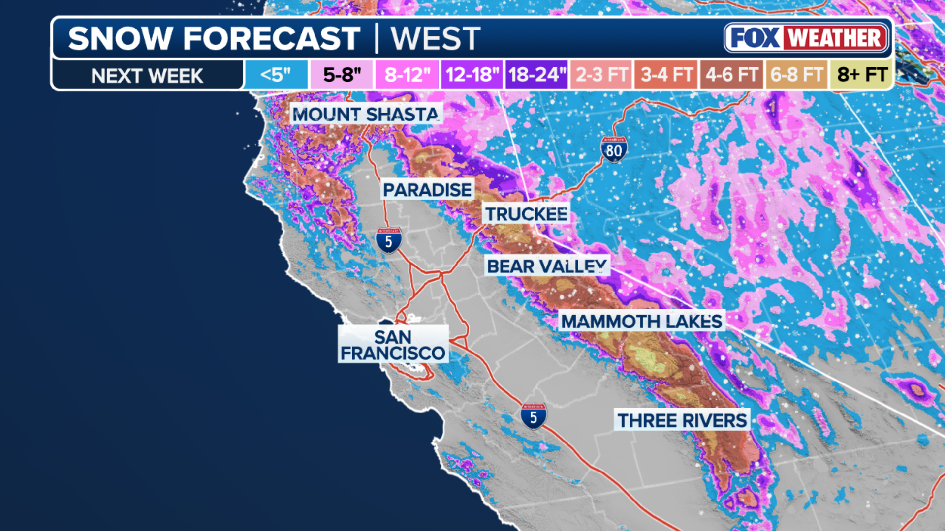 Snow forecast through next week. (FOX Weather)
The FOX Forecast Center predicts rounds of snow through the end of next week, with some areas in the mountains expected to see extreme totals of feet of snow in the double-digits. This will provide critical relief to the snow-starved regions across the Sierra, Rockies, Colorado Basins, and Wasatch ranges. 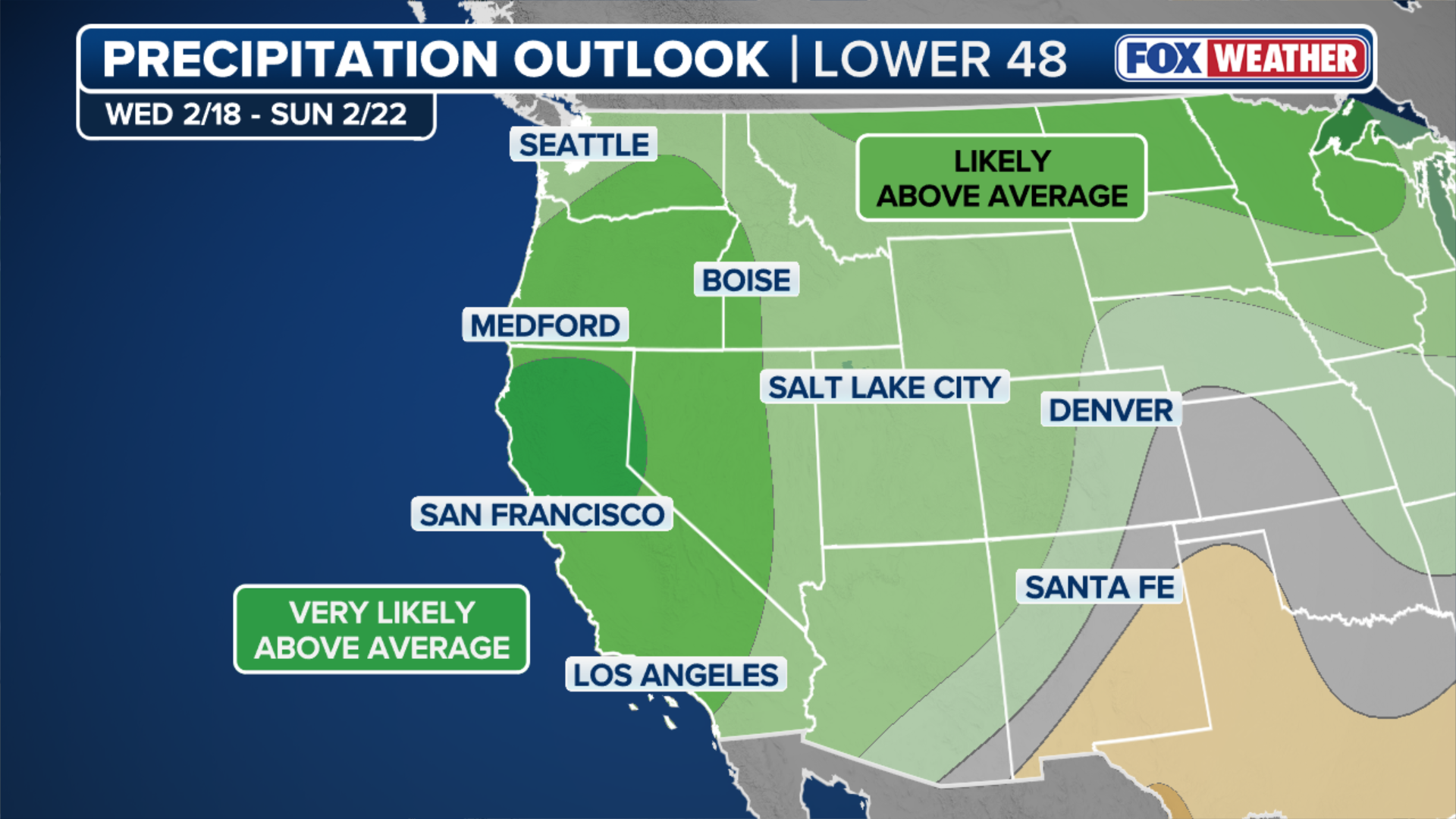 The precipitation outlook for next week. (FOX Weather)
Lower Elevation Impacts and Flash Flooding Risks
In the lower elevations, such as Southern California, heavy rain is expected starting early in the week. Los Angeles, CA, and San Diego, CA, could see up to 5 inches of rain, potentially causing flash flooding. This is especially likely near burn scars from last year’s devastating wildfires.  FILE- SANTA MONICA, CA – MARCH 12, 2025 – – Workers walk along Pacific Coast Highway, at Estrada Dr.., minutes before the highway was shutdown in Santa Monica on March 12, 2025. (Getty Images)
As for right now, there is only a ¼ flash flood threat in place. Even after this storm passes, the NOAA Climate Prediction Center predicts that much of the West will continue to see an above-average amount of precipitation through the end of February.  Downtown Los Angeles was wet again on Saturday, Jan. 3, 2026, as another storm passed through the Southland. (Myung J. Chun / Los Angeles Times via Getty Images) / Getty Images
Stay with FOX Weather to get the latest on the rain and snow in the West. For more information, visit Here
Image Source: www.foxweather.com
