
Severe Weather Strikes Southern Plains: Tornado Rips Through Purcell, Oklahoma
A radar-confirmed tornado tore across Interstate 35 and part of Purcell, Oklahoma, on Thursday morning, leaving a trail of destruction in its wake. The powerful storm knocked down power lines, causing outages and gas leaks, as a powerful line of thunderstorms barreled their way across the Southern Plains. Fortunately, no one was injured, but western parts of the city suffered damage, according to Purcell Police, who spoke to FOX Weather.
Storm Damage and Response
Purcell Police Chief Bobby Elmore reported that the storm moved northeast across the city, knocking down light and power poles around 7:30 a.m. local time. The City of Stillwater sent mutual aid to Purcell, and two schools were closed due to power outages, according to the Purcell Public Schools Superintendent. Video from storm trackers showed tree limbs strewn across houses, and a semi-truck was flipped on its side by the severe weather.
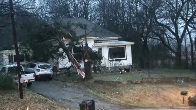
A radar-confirmed tornado ripped across Interstate 35 and part of Purcell, Oklahoma Thursday morning, knocking down power lines as a powerful line of thunderstorms barreled their way across the Southern Plains.
(KWTV/KOTV / FOX Weather)
Severe Weather Outlook
Storms are ongoing across parts of the Southern Plains, and NOAA’s Weather Prediction Center has issued a Level 2 out of 5 risk of severe thunderstorms from Oklahoma City to Tulsa, including the potential for more tornadoes. A Tornado Watch was in effect for parts of Oklahoma, Arkansas, and Missouri through 12 p.m. CT. The National Weather Service office in Norman confirmed at least EF-1 tornado damage in the Purcell area.
 A three-hour radar loop. Yellow shaded areas denote a Severe Thunderstorm Watch while red shaded areas denote a Tornado Watch. Warning boxes are color-coded as: Severe Thunderstorm Warnings in yellow, Tornado Warnings in red, Tornado Warnings with confirmed tornado in purple, Flash Flood Warnings in green, and Flash Flood Emergencies in pink.
(FOX Weather)
Conclusion
More severe storms are possible Thursday across the Mississippi River Valley from St. Louis to Oklahoma City and as far south as Monroe, Louisiana. These storms are being driven by a cold front moving ahead of a powerful cross-country system that is set to bring rain to millions across the Plains, Mississippi Valley, and Midwest. For the latest updates and information, visit Here
Image Source: www.foxweather.com
