
Hurricane Season Heats Up: FOX Weather Tracks Multiple Storms
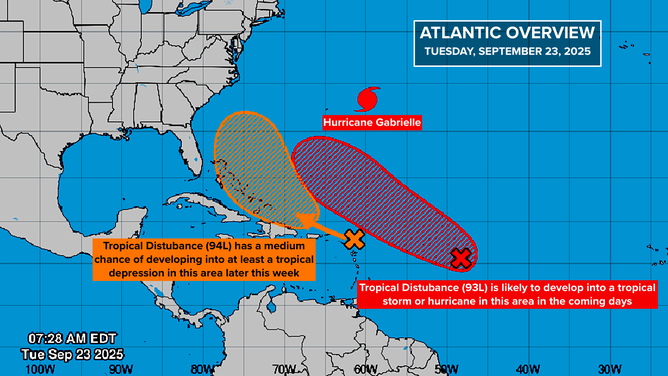
As Hurricane Gabrielle accelerates away from Bermuda, attention is shifting to two tropical disturbances, tagged Invest 93L and 94L, east of the Caribbean. Both have a good chance of developing late in the week or over the weekend, according to the National Hurricane Center (NHC). Systems designated “invests” are just disturbances, but they have sufficient organization that the NHC can run specialized computer models and analyses on them.
FOX Weather is your Hurricane HQ.
Invest 93L: A Potential Threat to Bermuda
Invest 93L is a large disturbance embedded in a cloud of dry air and Saharan dust, which is slowing its development. However, there is a strong consensus in the various computer forecasts that the system will break free of the dust as it tracks north in the general direction of Bermuda. The NHC has followed suit and has the odds of development in the very high range.
This graphic shows development odds for invests 93L and 94L in the Atlantic on Sept. 23, 2025.
An unusually high percentage of the potential tracks show the system developing into a large, strong hurricane in the general vicinity of Bermuda in about a week. Everybody on the island should stay in close touch with the forecasts once the system develops. The next two names on the list are Humberto and Imelda, and unless something unexpected happens with Invest 94L, Invest 93L will likely become Tropical Storm Humberto in a few days.
Invest 94L: A Disturbance to Watch
Invest 94L is finally breaking free of the hostile upper winds emanating from Hurricane Gabrielle, and the weather pattern is becoming increasingly conducive to the system organizing. It’s moving over the northeastern Caribbean islands and will reach the Virgin Islands and Puerto Rico tomorrow.
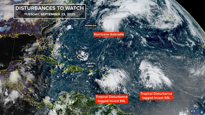
This satellite image shows Hurricane Gabrielle, and invests 93L and 94L in the Atlantic.
Flooding has been a concern on Puerto Rico with recent heavy rain, which will increase with this additional deep tropical moisture. El Yunque Peak, the 3,500-foot mountain in the center of the island, will be a deterrent to the system developing quickly but will also enhance the rainfall on its windward slopes.
When the disturbance arrives over or near the southeastern Bahamas about Thursday, there is a reasonable consensus in the computer forecasts that the system will begin to organize. The NHC gives Invest 94L a medium chance of developing into at least a tropical depression.
Hurricane Gabrielle: A Powerful Storm
On its current forecast track, Hurricane Gabrielle will be in the general vicinity of the Azores late Thursday or Friday. Residents there should stay in close touch with the latest forecasts and local instructions. Gabrielle is currently a powerful Category 4 storm but is forecast to start weakening tomorrow under more hostile upper winds and over cooler water.
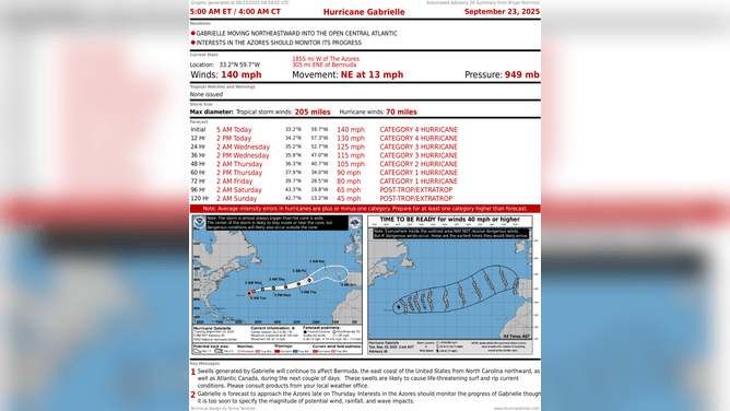
This image shows information on Hurricane Gabrielle in the Atlantic.
The remnants are forecast to be near northwestern Spain and Portugal early next week. For the latest updates and forecasts, visit Here
Image Source: www.foxweather.com
